Tag Archives: new orleans streets

St. Charles Avenue

The Gist: St. Charles Avenue was named after King Charles III of Spain, who was in power when Spain acquired New Orleans in 1763. It’s not necessarily named after a saint, but the Spanish monarch.

Yesterday: St. Charles Avenue has become one of the most iconic avenues in New Orleans, yet it was nothing more than a swampy frontier in 1822. John Chase writes, “St. Charles street was best known to the boys, who sought in sport for snipe among the latanier in the marshes, which had never been disturbed otherwise in their original growth” (122). He says that eventually St. Charles Avenue would be become the American Sector’s “lifeline.”

The original St. Charles hotel built two blocks from Canal Street in 1837. It was designed by famous architect, James Gallier and was one of the first great American hotels in the country. In 1851, it burned down in one of the city's great fires. It was rebuilt without it's iconic dome. It also would burn down in 1894.

The original St. Charles Hotel built two blocks from Canal Street in 1837. Designed by famous architect James Gallier, it was one of the first great American hotels in the country. In 1851, it burned down in one of the city’s great fires. It was rebuilt without its iconic dome, yet would burn down again in 1894.

It seems that St. Charles Avenue was always bustling with activity and prosperity even since its conception. Drinking was big then as it is today. Chase says that a library owner installed a bar among the bookshelves so that his library could survive. And, it most certainly did after that. Chase says that the avenue “was a gay, bright, and lively street with an air of exciting bohemianism about it” (212).

A railroad connected New Orleans and the town of Carrollton (the former Jefferson Parish seat and now the Riverbend area of Uptown New Orleans), prompting growth along the route. This is how St. Charles Avenue grew across what was once a row of plantations. This railway is still in use today as the St. Charles streetcar line, which is oldest working railway in the world.

A streetcar rolls passed The Holy Name of Jesus Church on Loyola University's campus. Tulane University is adjacent to the church, and the beautiful Audubon Park is across the street.

A streetcar rolls passed The Holy Name of Jesus Church on Loyola University’s campus. Tulane University is adjacent to the church, and the beautiful Audubon Park is across the street.

Today: Just as it was the major avenue for the American sector of the Faubourg Ste. Marie (now the CBD), it remains the primary Uptown route with homes, restaurants and bars, shops, universities, parks, and businesses. On this street, one can really see the diversity of New Orleans. You will see lawyers and businessmen wearing suits alongside service industry workers in chef shirts or serving aprons. People of all races, economic classes, and backgrounds can be seen along St. Charles Avenue.

St. Charles Avenue undergoes a traffic circle at Lee Circle. Named after Confederate General Robert E. Lee, Lee Circle remains a popular destination to catch parades. Notice the row of port-o-lets at the bottom of the picture.

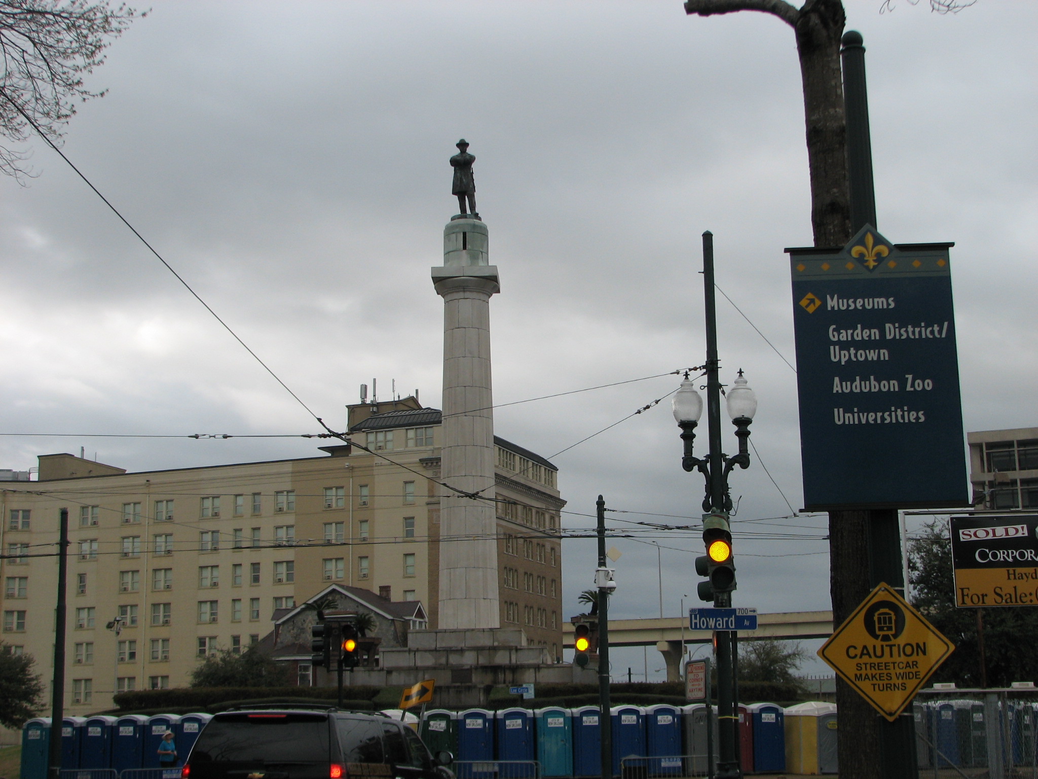
St. Charles Avenue at Lee Circle. Named after Confederate General Robert E. Lee, Lee Circle remains a popular destination to catch parades. Notice the row of port-o-lets at the bottom of the picture.

From Canal Street to Calliope Street (near the Pontchartrain Expressway Overpass), the avenue is full of law firms, skyscrapers, hotels, banks, fine restaurants, and town parks (like Lafayette Square). It then curves all the way to the river, intersecting with Carrollton Avenue in the Riverbend section of Uptown. It passes Tulane and Loyola universities, Audubon Park, and countless bars and restaurants.

The St. Charles streetcar line is still a major mode of transportation for locals and tourists alike. On a nice Spring afternoon, the streetcars will be at capacity with riders enjoying the views of century-old live oaks and elegant homes (some Antebellum). Most American cities refer to these transportation cars as “trollies;” however, we call them “streetcars.” The green streetcar along the St. Charles route has become an iconic symbol of New Orleans. Children commonly have birthday parties aboard them.

Since carnival season is in full swing, it is also good to mention that St. Charles Avenue has become a standard route for most Mardi Gras parades due to its wide neutral ground (or median) that can accommodate large crowds. Though several krewes parade down St. Charles Avenue two weeks before Mardi Gras, the most popular parades lead up to Fat Tuesday. On Thursday night, Muses (a krewe exclusive to women) rolls. Bacchus (one of the few “super krewes”) rolls the Sunday before Mardi Gras and features a famous celebrity as the Grand Marshal each year. Orpheus runs on “Lundi Gras” (or the Monday before Mardi Gras), while the Zulu and Rex parades roll on Fat Tuesday. During carnival season, beads get caught in tree branches and power lines and decorate the avenue until the next carnival.

Clockwise from top left: Mardi Gras beads hanging year round in trees along parade routes; the Bigshot float in the Zulu Parade, seated ladders are a common site along St. Charles during Mardi Gras; the Buoef Gras float in the Rex parade.

Clockwise from top left: Mardi Gras beads hanging year round in trees along parade routes; the Bigshot float in the Zulu Parade; seated ladders are a common site along St. Charles during Mardi Gras; the Boeuf Gras float in the Rex parade. Credit for Boeuf Gras and Zulu pictures: Chris Graythen, Getty Images.

Zulu is a historic African-American parade that runs on the early morning of Fat Tuesday. This krewe was not allowed to parade publicly until 1968. Run by the Social Aid and Pleasure Club, Zulu has both white and black riders that dress in grass skirts and have black face. This event is most likely the only occasion in America (if not the world) when white and black people wear blackface together and it be not only tolerated, but celebrated. As I’ve said before, we do things a little differently down here.

The Krewe of Rex is also a historic parade that first took to the streets in 1872. It brought stability to the carnival season at a time when the city considered eliminating carnival due to chaos and disorder, and they continue to do things for the public good (as their motto “Pro Bono Publico” suggests). Rex’s iconic Boeuf Gras float symbolizes the medieval routes of carnival. Historically, many European (typically French) cultures used to parade cattle down the streets and into the slaughterhouse for one last feast before fasting for Lent. In fact, Rex paraded live cattle in the parade for many years as well. Dr. Stephen Hales from the Rex Organizations says, “The Boeuf Gras is the oldest symbol of carnival, going back to the Middle Ages. In fact, back then they called it Boeuf Gras, not even Mardi Gras. If you took a 14th-century Frenchmen and parachuted him into New Orleans during Mardi Gras, he would be baffled as to what was happening, until he saw the Boeuf Gras float. Then, he would know exactly what was being celebrated.”

Tomorrow: St. Charles Avenue can appear as a time capsule with the streetcars, century-old mansions, and oak trees; however, new developments are always transforming the grand street. According to http://www.nola.curbed.com, a new grocery is being planned at 2025 St. Charles Avenue and will supposedly have a “beer cave,” coffee station, and a walk-in cigar humidor. These are a few of my favorite things, it just so happens.

As far the future of St. Charles Avenue goes, I do not foresee any significant changes, and I think mostly every New Orleanian is 100% content with that as well.

Am I wrong?

Sources:

John Chase. Frenchmen, Desire, and Good Children. 1949.

Sarah Chase. “New LGD Grocery Will Have a Walk-in Humidor and ‘Beer Cave.’” http://www.nola.curbed.com. 15 January 2014.

http://www.rexorganization.com

http://www.old-new-orleans.com/NO_StCharlesHotel.html

Esplanade Avenue


The neutral ground is rather large near the river, whereas it is narrow as you near Bayou St. John.

The neutral ground is much larger starting at the river, but it becomes a narrow strip of monkey grass at N. Miro Street near the Gayarre Place statue.

The Gist:  Esplanade Avenue gets its name from a Spanish military esplanade that ran from Fort St. Charles (where the U.S. Mint building is today) to Fort St. John (which used to be at the intersection of Barracks and Rampart).

Yesterday: Like most things New Orleans, it’s not a simple story. As most American stories begin, it starts with the Native Americans. What we know now as the “Esplanade Ridge” is a naturally high ground that the Indians used for portage between the Mississippi River and Lake Pontchartrain via Bayou St. John. Once John Law’s Company of the West planned the layout of New Orleans, this area was mandated that it be left undeveloped to allow for common defense of the new town. During the French colonial period, this area became later known as the “City Commons,” which was a plantation that was commonly owned and operated by five different owners. So, it did not go over well with the landowners when the Spanish came to power and decreed that the land be used directly for defense and built Fort St. Charles at the river and Fort St. John at (what is today) the intersection of Barracks and Rampart. They sued the Spanish King to no avail. By 1803, when the Louisiana Purchase commenced, the Spanish fortifications had fallen into disrepair. Since the area originally belonged to the French, the U.S. reasoned that the land was now theirs. Fort St. Charles had some influence leading up to the Battle of New Orleans, but the city did away with it by 1821.  The U.S. Congress than decreed that the old “City Commons” be divided up into new subdivisions to allow for expansion. The descendants of the “Creole” people of New Orleans expanded out from the French Quarter, since the American Sector was beyond Canal Street. It later became an avenue of great architecture and wealth, very similar to the American St. Charles Avenue. Several Catholic schools, such as St. Aloysius (which later merged with Cor Jesu to form Brother Martin in Gentilly), were established along the “Promenade Publique” as it was commonly called.

Of course, the story doesn’t end there. The U.S. Mint building would then take the place of Fort St. Charles; therefore, the city would give that building to the federal government. Ironically, Major P.G.T. Beauregard, who would later side with the Confederacy and command the forces at Fort Sumter, suggested extensive repairs be made to both stabilize and “fire proof” the building (Christovich 15). Once the Civil War broke, the city then seized the mint back from the federal government. Once General Farragut captured New Orleans, General Ben Butler occupied it, and the union seized the mint back from the city. As time went on, Esplanade Avenue would soon have a rail-line connecting the river to Bayou St. John, so residents could travel to the “pleasure gardens […] on sites of early plantations at the bayou” (Christovich xix). The elegance and atmosphere of this street would attract several artists including French Impressionist Edgar Degas.


This area was an old Indian Market. Several other triangular parks adorn Esplanade Avenue.

Esplanade splits left and Bayou Road splits right just after N. Miro Street. Gayarre’ Place was once near an old Indian Market. Several other triangular parks are along Esplanade Avenue as a result of centuries of boundary line disputes.


Today: Esplanade Avenue runs from the Mississippi River and ends at Bayou St. John. It borders unique neighborhoods such as the Vieux Carre, the Fauborg Marigny, and the Treme. It has something for everyone. Lavish homes, museums, quaint B & Bs, music venues, horse races, festivals, dive bars, coffee shops, green space, cemeteries, and dining establishments. The U.S. Mint building is now a Louisiana State Museum and its grounds host several musical festivals such as Satchmo Summer Fest and the Cajun-Zydeco Music Festival. Esplanade is the entrance to the booming music scene on Frenchmen Street in the Marigny. Every spring, the Crescent City Classic route follows most of Esplanade into City Park, and over 20,000 runners gaze at its unique features as they run by. The Degas House is a B & B that has been restored to honor the artist’s and the neighborhood’s history. Just a few blocks off the main street, the historic Fair Grounds Race Course run horses from Thanksgiving to March and host the immensely popular New Orleans Jazz and Heritage Festival that kicks off the last weekend in April and ends the first weekend in May.

Esplanade crosses Bayou St. John and ends at a small traffic circle on Wisner Boulevard, which soon turns into North Carrollton (going towards the river). The circle revolves around a statue of General P.G.T. Beauregard who once lived on the avenue and would later promote the Louisiana Lottery. Where the attractive gardens once were beyond the bayou, City Park gives residents the opportunity to have picnics, play sports, and bicycle among many other activities. The New Orleans Museum of Art is one of the grand views from the foot of Esplanade Avenue. Although a rail line no longer runs the length of the avenue, the City Park line (a part of the Canal Streetcar line) ends at the park, so residents can still access Esplanade and the bayou.


Cresson House (built around 1902). Several houses along Esplanade Avenue are unique.

Cresson House (built around 1902). Several houses along Esplanade Avenue are unique.

Tomorrow: Also, like most things New Orleans, the story isn’t over. In the book, New Orleans Architecture: The Esplanade Ridge, Christovich writes that Esplanade Avenue “is beautiful, it is grand, it is shabby and often frayed; it is struggling for new definition and survival” (xx). The eclectic avenue is all of those things and continuing to redefine itself. Paths to Progress, an intergovernmental partnership, is resurfacing many streets throughout New Orleans. The construction has ended on Esplanade, making the portion between the bayou and Claiborne Avenue one lane traffic to allow more parking area and a bike lane. Wheelchair curbs were also installed. Some residents have complained about the inconvenience of the construction and remain skeptical of the new development. Many believe that the one lane traffic will cause gridlock traffic, especially during Jazz Fest. That remains to be seen, of course, next year. The American Heritage Dictionary defines “esplanade” as being “a flat, open stretch of pavement or grass used as a promenade.” And, just as it originally began as a public space, New Orleanians still can enjoy Esplanade Avenue via foot, bike, or automobile.


Primary Source:  New Orleans Architecture: The Esplanade Ridge. Mary Louise Christovich, Sally Kittredge Evans, and Roulhac Toledano.

Canal Street

Canal Street

Canal Street

The Gist: Canal Street was named after a navigational canal that never actually came to fruition. It was also the original “neutral ground,” which is what New Orleanians call street medians.

Yesterday
Contrary to common belief, Canal Street was never a major navigation canal that was later filled in. There was once a stagnant ditch near there, which gave city developers the idea. Congress designated the wide area for a canal in 1807, but the Orleans Navigation Company basically screwed the pooch. As a street, it separated the “Creoles” from the vile Americans but yet provided a neutral area for commerce between the two clashing cultures. Many store employees were commonly bilingual. It would become home to America’s first movie theater in 1896 as well as department stores such as D.H. Holmes. Canal Street has been a common setting in literary works by authors such as George Washington Cable, John Kennedy Toole, Kate Chopin, and Walker Percy.

Today
Canal Street now runs from the Mississippi River to the Mid-city cemeteries. Towards the river, the street continues to be a retail hub for New Orleans and still separates two distinct worlds: the French Quarter and the Central Business District. On one side, historic brick buildings display ironwork balconies and Spanish architecture, whereas the CBD contains modern office buildings and skyscrapers. The traffic is typically congested due to construction work, buses, tourists, streetcars, and poorly-timed streetlights. Near the I-10 overpass, the street still suffers from blight due to Hurricane Katrina and the bad economy. The Joy Theatre and the Saegner Theatre have reopened since the storm. Streetcar tracks run inside the “neutral ground” of Canal Street. Ironically, the tracks were dismantled in the mid-20th century in an attempt to modernize the city with bus lanes. In 2004, the line was restored once the City of New Orleans realized they screwed the pooch on that one. Towards the lake, Canal Street is mainly residential with several local businesses, schools, bars, and restaurants. This part of Canal Street severely flooded during Katrina, yet many parts have rebuilt since then.

Tomorrow
The upcoming massive medical district, which includes the new VA hospital and University hospital, has the potential not only to provide residents with medical options and employment opportunities but also to boost the city’s economy and create a viable industry for the future.